


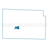
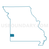
LAKESIDE Voting District, Jasper County, Missouri
About
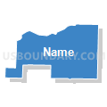
Outline

Summary
| Unique Area Identifier | 608763 |
| Name | LAKESIDE Voting District |
| County | Jasper County |
| State | Missouri |
| Area (square miles) | 4.89 |
| Land Area (square miles) | 4.89 |
| Water Area (square miles) | 0.00 |
| % of Land Area | 100.00 |
| % of Water Area | 0.00 |
| Latitude of the Internal Point | 37.16910110 |
| Longtitude of the Internal Point | -94.42624260 |
Maps

Graphs
Select a template below for downloading or customizing gragh for LAKESIDE Voting District, Jasper County, Missouri


Neighbors
Neighoring Voting District (by Name) Neighboring Voting District on the Map
- CARTERVILLE - ALL WARDS (1-4), Jasper County, MO
- MONITOR Voting District, Jasper County, MO
- ORONOGO 1 Voting District, Jasper County, MO
- WEBB CITY WARD 1 / WARD 4, Jasper County, MO
- WEST JACKSON Voting District, Jasper County, MO
Top 10 Neighboring County Subdivision (by Population) Neighboring County Subdivision on the Map
- Joplin township, Jasper County, MO (42,173)
- Marion township, Jasper County, MO (15,137)
- Mineral township, Jasper County, MO (9,100)
- Jackson township, Jasper County, MO (4,954)